PCT Day 116

Start: 1871.5

Stop: 1887 (+0.5 on side trail for Whitney)

Today’s miles: 15.5 (16 total)

Total PCT miles: 1739.2

Today was another phenomenal day! Although I spent it primarily alone, I’m currently not feeling lonely. I have a feeling the miles coming up will end up getting that way.. with most of the flippers finishing and all the SOBOs being so spread out.. my friends on either side of me.


Anywho-when my watch vibrated at 5:30am, I reached up and touched my tent wall to see if there was condensation.. there was: AND IT WAS FROZEN! I sat up, realized just how cold it was outside of my quilt cocoon, and I pushed snooze and snuggled back in. Shorter miles have to be good for something, right?!


When my watch vibrated at 6, I peaked across the way and saw that Miles’ tent was still up. I took out an earplug-didnt hear him moving, put my earplug back in and set an alarm for 6:45. I just could not move in that cold! I did finally start packing at 6:45 and left by 7:15, only a couple minutes after Miles. That couple of minutes difference means besides seeing his shape on switchbacks above, I didn’t see him again all day!
It was cold going, in the shade of the mountain.

The trail was still kind, even with the switchbacks.. they were graded and gentle, no huge rock steps except for every once in awhile. I filtered water within the first mile, but not from camp.. I needed to warm up a tad, get my heartbeat going, before touching ice cold water.

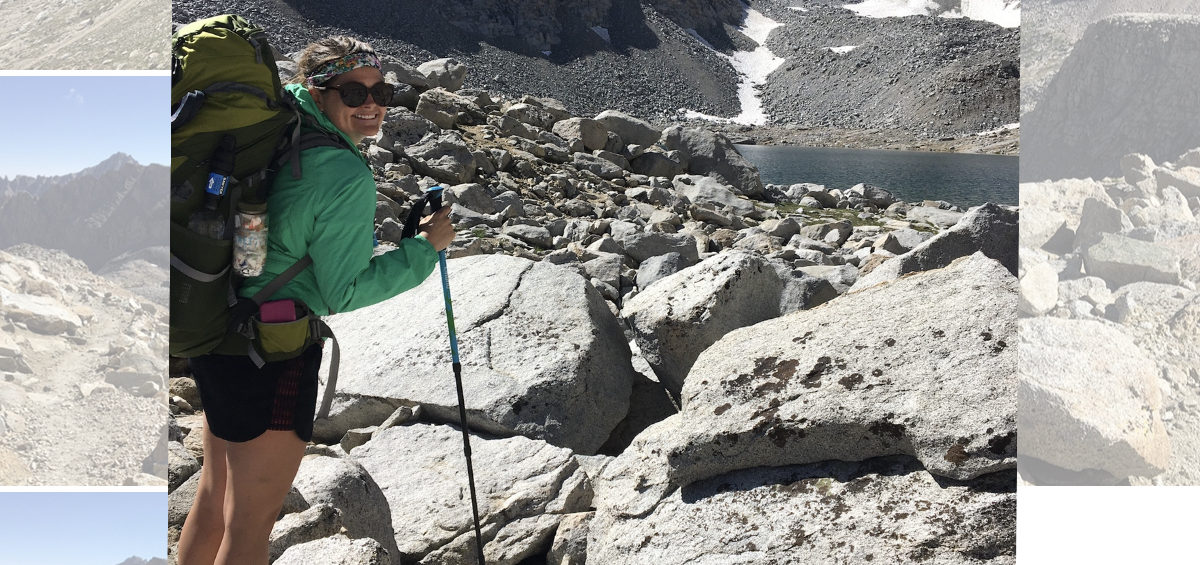
The views as I got higher were unbelievable. It was a rock covered fortress of mountain walls with snow and lakes all around. There was a small patch of snow I had to walk across, but someone on horseback had recently come through and covered the snow with dirt, making each step very stable. Then it was switchbacks up and around, up and around some more. There was a huge patch of snow on a ridgeline, but someone had made a trail to follow down below it, allowing me to completely avoid it. It was perfect, and spit me back out on a switchback.

The switchbacks up ahead had tons of snow along one side, so there were rock scrambles to get around them, and one section of rock and snow to get over, maybe 5-6 steps total on snow.. although it was more like ice. I made it to the top by 9:40, which, I was assuming it would take me until 10am-knowing I’d go slow because of the elevation. Forester Pass is the highest pass on the PCT, coming in at 13,120 feet.


I took some pictures at the top and had another hiker take a picture of me with the sign. I passed into my 7th national park at the top of this pass! I’m now in Sequoia National Park.. hard to believe I’ve made it so far! It feels so very surreal!


I started heading down the pass pretty soon after the other hiker left, simply because the air felt really thin and the best remedy to that was to get down! The switchbacks along the descent were steep until hitting the “floor” about 3/4 of a mile down. After that? The trail was GLORIOUS. Easy, smooth path twisting and turning around lakes and through trees and across water.. but never anything difficult. It went by so quick!


I had to take my shoes off for a creek crossing, so on the other side I ate lunch and left my shoes off and laid out my tent to dry that now soaking wet condensation. I sat around for 45 minutes or so, then packed up and kept moving. The afternoon held some climbs and descents, but nothing difficult and nothing that took my breath away.

I talked to a ranger with about a mile to go to get to camp. He said the weather should be good tomorrow, but that it changes very quickly. We chatted a few minutes about my hike and my plans, then went our separate ways. I hiked down the side trail half a mile before setting up camp. That leaves 15.2 miles total to go up Mount Whitney and back here tomorrow.


The odd thing is-I’m the only one camped here! I’ve seen several other people pass, but they’re all wanting to make tomorrow shorter, to where I’m more concerned about making the following day shorter-when I leave here and hike to Cottonwood Pass to get into town. Oh well. It’s a little unsettling here, I can hear a lot of creature movement outside.. but it is what it is and I hope I sleep well because I’m sleeping here tomorrow too!


In the morning, probably 6 ish, I’ll make sure to put everything in my pack liner and set it on top of my sleeping pad-scoot it all to the middle of my tent and pop up my umbrella over the bag-then when I take out my trekking poles and my tent collapses, I’ll tuck it and place rocks on the edges-in case it rains while I’m hiking.. hopefully that will keep everything inside safe and dry. Since I’m hiking up and back, I’m taking only my pack, water bottles and filter, snack foods, and clothes.. like rain gear. Anything I might need while on a mountainside.. but not my tent, pad, quilt, bear can, jet boil.. you get the drift..


Ok. Time to pop in my earplugs! Pray for good weather! Sweet dreams!

PCT Day 115

Start: 1854.2

Stop: 1871.5

Today’s miles: 17.3

Total PCT miles: 1723.7

Today was great! It’s amazing how much better you do and feel when you decide to listen to your body and slow down a bit.. and eat more calories. I slept fantastic, without earplugs, even.. the creek was the perfect white noise. When I was packing, Strider came and gave me one of her homemade dinners, because she should get into town this afternoon and won’t need it! HELL YES! Now I’ll definitely have enough calories to get me through the next several days!


We left camp at 6am and within a mile we hit the avalanche zone with a mile of mangled trees covering the trail. Yesterday, a hiker gave Strider directions for how to bushwhack around it all, by climbing up to the rocky ridge on the right hand side and following it along until after a stream crossing, then come back through the mess, cross the meadow, and reconnect with the trail. Thank God he told her, and she remembered it all so well, because it would have been a disaster if it were me leading us this morning.


We found the rock cairn and headed right, up a steep ridge, then carefully made our way around the chaos below. It was still slow moving, because the rocks were loose and sharp, making you really pay attention to every step, but it was way faster than climbing under, over, and around thousands of snapped trees and their roots. We crossed the stream, and when I saw the way Strider’s long legs had to leap off the last rock to make purchase with the ground on the other side, I got nervous. Eventually, she just reached for my arm and as I jumped, she pulled me, giving me the momentum to land safely on ground.. I would say solid ground, but it was most definitely not solid! Ha.


Before we came down off the ridge, I ended up needing to dig a hole. Classy. Strider carried on but still waited for me before getting too far ahead, to make sure I got back to trail ok. We talked and walked for a little while once back on the trail, and sadly we went ahead and said our goodbyes for now.. she is much faster on the ascents than I am, and she has to get into town today-I really didn’t want to slow her down! We snapped a selfie and made sure to swap numbers, and she was gone!


Including the bushwhacking business, it was 8.7 miles to the top of Glen Pass. I had been cold all morning, the trail always seeming to be in the shade of the mountains surrounding.. but I didn’t want to wear my nice jacket, rain jacket, gloves or beanie while bushwhacking. You know, incase something got ripped-and as it was creeping into later morning, I knew I should be warming up soon, walking uphill and all, but I stayed cold.

About 10am I made it to a level chunk of the climb: Rae Lakes! I saw the spot Andrea and I camped, near a ranger station, after I fell in a creek and busted my head. I had a pretty big goose egg and we were fairly certain I had a concussion, too. But we survived the night-I slept so good that night but poor Andrea was worried sick I’d die in my sleep. Oh, what fun times a first backpacking trip is!


Around the corner from that camp spot, I found a nice sunny lake overlook, so I filtered water, ate a snack, and rested. Before too long, it was time to get a move on the last few miles to the top of Glen Pass. It really wasn’t as bad as I expected it to be. I passed the creek I whacked my head in, this time I crossed without issue, praise. Then it turned into winding and twisting rock switchbacks.


I came to a false summit, only to start the real steep switchbacks. I passed a couple people and quite a few folks passed me. About 200 feet from the top there was snow. The top traverse looked very steep and less traveled, there was a middle one with slightly better boot track across, and then the bottom one was like a trench. Snow came up on either side of the “trail” to about my height. The inside of the trench was half melted out to rocks and the upper half still snow, but there were steps visible in it.


I rock scrambled down the jagged boulders to the trench then made my way through. I didn’t slip or slide, I took my time and stayed calm. I knew if I fell in the trench, I’d go no where.. but it would hurt like hell. Once on the other side, I had to rock scramble my way almost vertical to the ridge line above where the actual pass was. It was pretty dang scary, but so exhilarating! There were a few guys sitting up there and they congratulated me when I made it. It was just after 12pm.


I took my pack off and sat a bit, talking. Then, I headed down the other side. It was snow free and had a ton of switchbacks to start with. There had been a rock slide so the ground was very loose and the steps at times were a bit sketchy, but I never felt unsafe. If anything, the softness of the ground felt good on my feet. I was cruising down hill, surrounded by open sky and a tiny stream. When I got hungry for lunch, I realized I had already passed the last water source for a little while. Dang it.


As I walked and got closer to water, a day hiker caught up to me and we started chatting. He’s done the PCT and the CDT! We maybe walked together talking for close to 25 minutes before we got to the junction for Kearsarge Pass (also where Strider left out to get to town). He ended up giving me 4 protein bars! And then, as we said bye, we spotted another one that someone dropped! Holy crap! That’s trail magic AGAIN!


I thanked him profusely and then within half an hour I was posted up at a stream, water filtering, shoes off, and eating potatoes. I was going to eat Strider’s homemade ramen with spices and peanuts-but I decided I’d rather have it for dinner, so I can savor it more! I stayed resting after lunch a good 15-20 minutes, so close to an hour all in all, before I continued hiking. About a mile after lunch, I got to the valley floor, Vidette Meadows, and started the ascent that would eventually lead up to Forester Pass.


It was actually smooth going, the climb meandered and wandered calmly. I wasn’t expecting the trail to be so gentle. Not even a mile into the climb, I came across more trail magic! FOUR TIMES TODAY! This was a metal locker that a pack rancher left for hikers, because the pack animals had too much weight to carry so they had to lighten the load. I unlocked the box with the spoon provided and it was amazing! Oranges, Doritos, cookies, starburst! There were other things too, but I only took one snack pack of everything I named above. Oh how the trail provides!!


I kept climbing, getting closer and closer to my destination: 3 miles south of Forester Pass. With half a mile to go, I crossed paths with Pinecone and her boyfriend! The nurses from Reno that I met back at Shelter Cove! It was so fun to see them here, in the Sierra, almost done with their hike! We chatted a couple minutes and then carried on our separate ways.


I found the area I was aiming for, but at first the sites in the trees looked close to being all taken. Several older gentlemen were eating dinner and said I could fit in there near them no problem, but up around the corner there was more spots to choose from. So, I told them I’d go take a look and I might be back. They were protected from the wind, and at 11,256 feet of elevation, it’s cold-with or without the wind!


The spots up around the corner were too gorgeous to pass up. I chose one, then went to tell the guys and let them know if anymore SOBOs come up the hill they can tell them there’s at least 3-4 more spots near me. Then, I set up my tent. As I was staking it out, Miles showed up. He’s a hiker that will be finished in Kennedy Meadows South, so he’s super close to being done with his thruhike!


I unpacked and he set up his camp, then we ate dinner together watching the sunset, marveling at the views, and talking about trail life. He was very nice and I really enjoyed the company, especially my first night away from Strider. Hiking with her helped my mood tremendously after separating from Margot back before Donohue Pass. Now, it’s like Miles is helping alleviate the ache of being separated from Strider now too.


I ate the meal that Strider made, and it reminded me of pad Thai, with the peanuts and peanut butter.. plus she had soy sauce AND lime juice powder! Holy hell it was incredible! Instead of rinsing my bowl like normal, I literally licked it to get all of the spices left on the sides! Ridiculous, I know, but my god it was DELICIOUS!


Now I’m all tucked in my quilt, glad it’s keeping me warm, because it’s cold as hell out there! I hope tomorrow goes well.. should be relatively “easy” in the sense of I’m doing less miles than today. Although it is the highest pass on the PCT.. ha, we’ll see how it goes! Goodnight!

PCT Day 114

Start: 1833.2

Stop: 1854.2

Today’s miles: 21

Total PCT miles: 1706.4

My dogs are barkin! At lunch today, Strider looked at my food with me to make sure I wasn’t setting myself up for failure. The last two days have consisted of me not eating nearly enough calories for the work I’m putting in, but I also think I need to add another day, stretching my low amount of daily calories one more day..

I do have enough to get me to Cottonwood Pass and do Mount Whitney.. but I split up one of the days because after today I realized it’s just too dang much! If I’m wrong, no worries, I’ll just keep hiking and make a new plan, but for right now.. slowing down the next 3 days over the hardest 2 mountains sounds way better to me than my original plan. Oh, the Sierra! Always ready to blow your mind and make you lose your mind too!


I ended up pushing snooze this morning for 10 extra minutes.. I yelled to Strider to let her know, so she wouldn’t be out packing her tent in the dark while I was snoozing still haha. I finally started moving at 5:40 and we were both packed and on trail by 6:10. Not too bad at all! As we started walking, our headlamps put away since it was bright enough (just barely) to see the trail, I told her about my 3:30am adventure, and how I almost screamed for her because I scared myself so bad..


I woke up at 3:30 and had to pee. Like bad. So, I put on my crocs and get my KulaCloth and head outside my tent. We’re camped on sandy rock between massive slabs of rock.. with a couple bushes around. I remembered from setting up that I needed to go on the slab, around the bush, and down some-and then I’d be on scrub brush and sand-not rock.


So I do. And I pee. And then I get so completely disoriented that I couldn’t find my way back to my tent. I walked slowly, felt for the bush.. noted that the rock I was back on was now suddenly sloping wayyyy down and not in a safe way. I literally started to panic and almost screamed, like her name was coming out with the next breath, when I realized I was standing right at her tent! One more step and I would have probably kicked Strider! I was so happy I found it that I almost fell into it! She’d really think I was a lunatic. Instead, I grabbed on to the bush beside her tent, slowly stepped around and over her guylines, and safely made it back to my tent. What in the whole hell?! No wonder I pushed snooze. I think the elevation had something to do with it, surely. Right? Ha


Anywho. We had 4 miles to the top of Mather Pass at 12,094 feet. I had been stressed about this one because of the snow comments-but-it was completely fine. The first 2 miles were meandering through alpine meadows, water was everywhere, there was a lake, and we were in the bowl of all of these massive mountains. We could see the sun shining on other areas, but it wasn’t high enough in the sky to warm up anything in the bowl we were in.


The next mile was tough, but the last mile about did me in. It was slow moving on trail surrounded by massive boulders. Up big stone steps and then crunching on loose gravel the size of coke cans. It switchbacked and became steep. There was a section with snow, hard as ice in the cold shade we were in. It had partially melted out in some places, so big sharp rocks were protruding through.. I had to step on the snow, not slip, step onto rock, and climb upwards too. It was maybe a total of 20 or so steps.. which I handled fine without microspikes. Once the snow ended, I had to rock scramble back up maybe 20-30 feet to the trail. Then onwards up I went.


The top was stunning all the way around, valleys on either side of the pass, one sunny and one still in the shade, both spectacular. I stayed up top only long enough to get sunscreen on and my sunglasses out, then I started the descent. It switchbacked down and had a little snow to go over too, but only one spot-everything else I could literally walk or scramble easily around. I met a guy doing the JMT and we walked and talked until I caught up to Strider, filtering some water.

She and I hiked through this valley together, 4 or 5 miles down before climbing again another 4 up Pinchot Pass at 12,127 feet. Two passes in one day! The valley stayed in the alpine zone, so it was cool and less buggy than the other valleys have been. I was so grateful. Lakes and scrub brush and tiny bits of grass all growing on rocks and sand. It’s seriously out of this world gorgeous.

We ate lunch with 3 miles to go to the top of the pass, only because I was getting dizzy and couldn’t walk much farther for fear of passing out. I was happy Stridor agreed to still eat with me, she usually eats her lunch an hour or so later than I do.. and I haven’t been eating enough calories in general through this stretch, so there was no way I’d have made it another hour.
I ate ramen for lunch, and it honestly really helped me get up to that pass.

Those last 3 miles took me almost 2 hours, but I was still moving faster than this morning. The rocks were steep, but the ascent had no snow that couldn’t be walked around. There were at least 3 incredible lakes, all snowmelt, that we walked by.. or climbed by I guess. The top was just as fascinating as Mather Pass, the beauty unbelievable. I was mesmerized. If there wasn’t all this beauty at the tops of these climbs, I don’t know that I’d do this at all. It makes everything so completely worth it.


I started the descent and was moving pretty quick on the switchbacks. It was still rock trail, but it was sandier and easier to walk on for awhile. Before it turned into huge rock steps.. those hurt. The views went from those gorgeous alpine meadows with water everywhere and birds chirping, to hot valley with a raging river next to the trail, and eventually into the forest. We were supposed to try to climb some of Glen Pass today, but when I finally caught up to Strider again, we were still a good ways away from the bottom of the descent, and it was getting closer to sunset.


Apparently the start of the climb has some significant avalanche damage. To the point it can take hours to get through. A man told Strider how to climb around it, and we did not want to get stuck in that with the sun setting. So, we’ll get to tackle that first thing in the morning I guess. We have a horrible 8.7 miles to the top of Glen Pass, then on the descent, Strider will take the junction over Kearsarge Pass to get into the town of Independence, California, and I’ll keep hiking towards Forester Pass. I’m aiming for less than 20 miles tomorrow and the following 2 days.. and then it’ll be about 20 miles exactly to get to Cottonwood Pass after Mount Whitney.


Let’s pray tomorrow goes well, I’m stressed about the avalanche debris and the fact that I’ll be hiking uphill for close to 9 miles. Yikes. In that case, time to get some sleep, 5:30am comes way too early for me!